Bell Trail
This hike goes to the Mogollon Rim but I only went as far as the stream crossing on Wet Beaver Creek. The hike to the creek and back is about 7.5 miles and the Mogollon rim would have been 12 miles round trip, that's a little long for my old legs!
It was nice that they posted the history of Bell Trail.
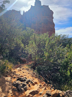
Lots of iron in the soil in this area, it looks beautiful in the sunlight!
The canyon seemed to go on forever!
I decided to try out the panorama view again, this whole valley is gorgeous!
This is supposedly also a mountain biking and equestrian trail.
The trail is narrow and has a steep drop off and a sheer cliff on the other side.
I could see horses from this point to the creek but I can't imagine a mountain bike making it through some of this area.
There was a long section of the trail that was basically a ledge on the side of the mountain.
The natural step formations are interesting to say the least!
The ocotillo's are super bright orange back here!
This is where the trail crossed the creek to the Mogollon Rim. I would want to have a hiking partner to go past this point because I doubt anyone would even know that you're back there if something bad happened to you.
Click the photo above to see my video!
I was surprised to see the century plants growing from the agave, the ones in Mesa had already seeded and died by now.
I had seen a sign on Bell Trail for a spur called Weir Trail, this is where the trail got it's name.
I took this photo on the way out because of the position of the sun, the rocks seemed to be a brighter orange!
Of course I couldn't resist the chance to get photos of the prickly pear cactus blooms!
There was only 4 vehicles when I started my hike at 7:30 and by the time I got back 4 hours later the parking lot was completely full and several cars in the overflow lot up the road.
V-V Petroglyph Site
This was the entrance to the Petroglyph site which was about 2 miles down the road from Bell Trail. The hike from the Visitor Center to the petroglyphs was about a 2 mile hike round trip.
This site was originally inhabited by the Sinagua people between AD 600 - 1400.
This is some of the history of the V Bar V ranch.
This is some of the history of the Sinagua people and their artwork. This site is one of the largest and most preserved sites in the Verde Valley. Fortunately the ranchers were great stewards of the land and the site and for the most part the petroglyphs weren't even known to many people since they were located on private land.
There was a ranger on site to explain the petroglyphs and answer questions about the history of the site and the ranch itself.
There are lichens growing on the walls here, the apparatus in this photo is designed to take photos in 10 mm increments to measure and plot the growth of the lichens.


2 comments:
Great pictures and history of the place. It's really cool reading about it, thanks 😊.
Glad you enjoyed it Aunt Patti!!
Post a Comment