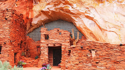
24.06.24 Monday---Today we moved to Bryce-Zion Campground and saw this interesting little museum so we pulled over, with very little room in the parking lot, but we squeezed in anyway. It was a fun little stop!

Moqui Cave has quite a unique history- The late Garth and
Laura Chamberlain purchased the cave in 1951 and turned it into Southern Utah’s
first dance hall and bar. During the week, you could grab a bite to eat and
something cool to drink at their fully functional bar and a live band would
come play on Friday and Saturday nights. The temperature of the cave never goes
above 65 degrees.
The cave operated as a speakeasy during the 1920s
Prohibition and into the Great Depression. Garth Chamberlain (born and raised in Utah) bought the
property “from a local rancher” in 1951.
Chamberlain and his wife Laura leveled the floor and
re-fashioned the location as a bar and dance hall, with live music. It was a
unique stop for visiting Hollywood stars that were shooting western films in
the area, and a favorite watering hole of the Glen Canyon Dam construction
workers. This went on for about two decades, until Garth and Laura started
converting the place to a museum.
A museum was always what they wanted to do, as Garth studied
Geology, Archaeology, and Paleontology. The exhibits on display are his
personal findings after years of studies and collecting. They include more than
1,000 arrowheads, ceremonial points, jugs, pots, bowls and working tools from
the Puebloan Era. There is a large collection of dinosaur tracks and fossils,
most of which were found in the surrounding area. Their fluorescent mineral
displays is one of the largest in the U.S.


The back part of the cave where dances were held.
A small part of the fluorescent
mineral display.
A small part of the dinosaur track display.
I just thought this mineral was so pretty. Honeycomb Calcite
Al found a cave to explore and went wandering...
AFTER SETTING UP MONA…we drove to Zion, got info from the
visitor center, stopped at several scenic vistas and drove back through. There
are some gorgeous areas, lots of curvy roads and a couple of tunnels.
Tuesday June 25, 2024
The Sunrise from the camper
We drove to Kanab to the visitor center where we got a
recommendation for lunch and a drive. Well, the lunch left a lot to be desired.
The visitor center guy said it was a really good buffet and better than Pizza
Hut. Ok, we thought we’ll try it. Lotsa Motsa Pizza turned out to be a hole in
the wall, picnic tables, all sit together, food all over the floor in front of
the buffet, paper plates (reuse the one you have), plastic forks… but it was
only $6.99 each. The food… I had a big salad because that looked pretty good.
Al started with pizza. I guess I got used to Pizza Ranch. They had some
cinnamon sticks that were ok and I ate the toppings off two slices. Al
continued with salad and chili. I used the restroom… a shared men-women
restroom…one. I won’t describe it, you can guess.
Best Friends Animal Sanctuary
The “Disney barn,” still at the Sanctuary today, was
a set for the 1973 film One Little Indian, starring James Garner and 9yo Jodie
Foster. Dozens of movies and TV shows filmed in the canyon, like The Lone
Ranger, The Outlaw Josey Wales, “Lassie” and "Gunsmoke.”
We turned onto Kanab Canyon Road…a dirt road. We had a map and were told this is the Best
Friends Animal Sanctuary. We saw many horses right away and they had lots of
room to run and shelters for shade.
Our map showed many sites and trails inside the Sanctuary. We turned down one road (a smaller dirt road than the one we were on) and went looking for Indian Ruins and a Hidden Lake. We ended up on a dead end sand road after crossing a bridge that wasn’t wide enough for our truck. We decided to turn around before we got stuck in the sand and had no cell reception! Turns out I should have read a little closer, The map did say “You will need a 4WD.” Oops! Didn’t have my glasses on. No reception up there either!
Didn't want to get stuck up there in this heat!!!
This was on one side of the truck...
...and this was on the other...
The picture doesn't show it well but we had to drive slow and took up the whole width of the road.
Angel’s Rest—This is a scenic place of burial and
remembrance to celebrate the life and bond we share with animals. This cemetery
was absolutely huge! The “headstones” were each made with stepping stones
obviously made by the organization and each was decorated with colored stones.
There were wind chimes everywhere! And paths and benches, trees and bushes. A
beautiful place.
The pet cemetery was beautiful. Every little grave site had a stepping stone with a name and dates and pretty colored stones. Each and every one was loved.
The entrance to the cemetery.
A meditation path.
We continued on through the Best Friends Animal Sanctuary.
This place was just amazing. The sanctuary is on 3,700 acres. Every kind of
animal has its own area, considered neighborhoods, which includes Bunny House,
Dogtown and Cat World among others. Animals that are unable to be placed in
permanent homes and wild animals that cannot be released back into the wild can
live out their lives at the sanctuary.
I just had to take a picture of this for a special little furry friend.
Zion National Park
We came to this short tunnel and wondered what the big deal was about campers coming through here.
But then we came to this one! 1.1 miles long and if you were in a low clearance RV you had to get a permit and drive down the center of the road. They have a guard shack on either end to stop oncoming traffic until the RV gets through. The height clearance would be too low for Mona to even get through there!
We got to Zion at 8:00 am and the parking was all full! We had
to drive out of the park to Springdale (right outside the park), we found a
small parking lot and had to pay $40 for a spot that was too small for our
truck!
We were going to catch the park shuttle to take Al to the Trail Head he wanted to hike and then I was going to ride the shuttle, stop at a few sights and meet him back at the Visitor Center. Well.....
You can't see it in the following photo but there were hundreds of people waiting for the shuttle busses. SOOOO may people!!! And it was SOOOO hot!!! Never again. We stood in a very long line, in and out of sun/shade for well over an hour, zig zagging back and forth...and it was soooo hot! I could not believe the freaking crazy people who had small children and tiny babies in this line and they were going to go on a hike! One guy had a baby, couldn't have been much more than a few months old, in a back back kind of thing. It had a buggy type of shade over but it really was so hot!. The man drank a whole bottle of water while we were in line but not once did he check on that baby or give it anything to drink!
Finally, we got on a shuttle, standing room only, hanging onto a strap...
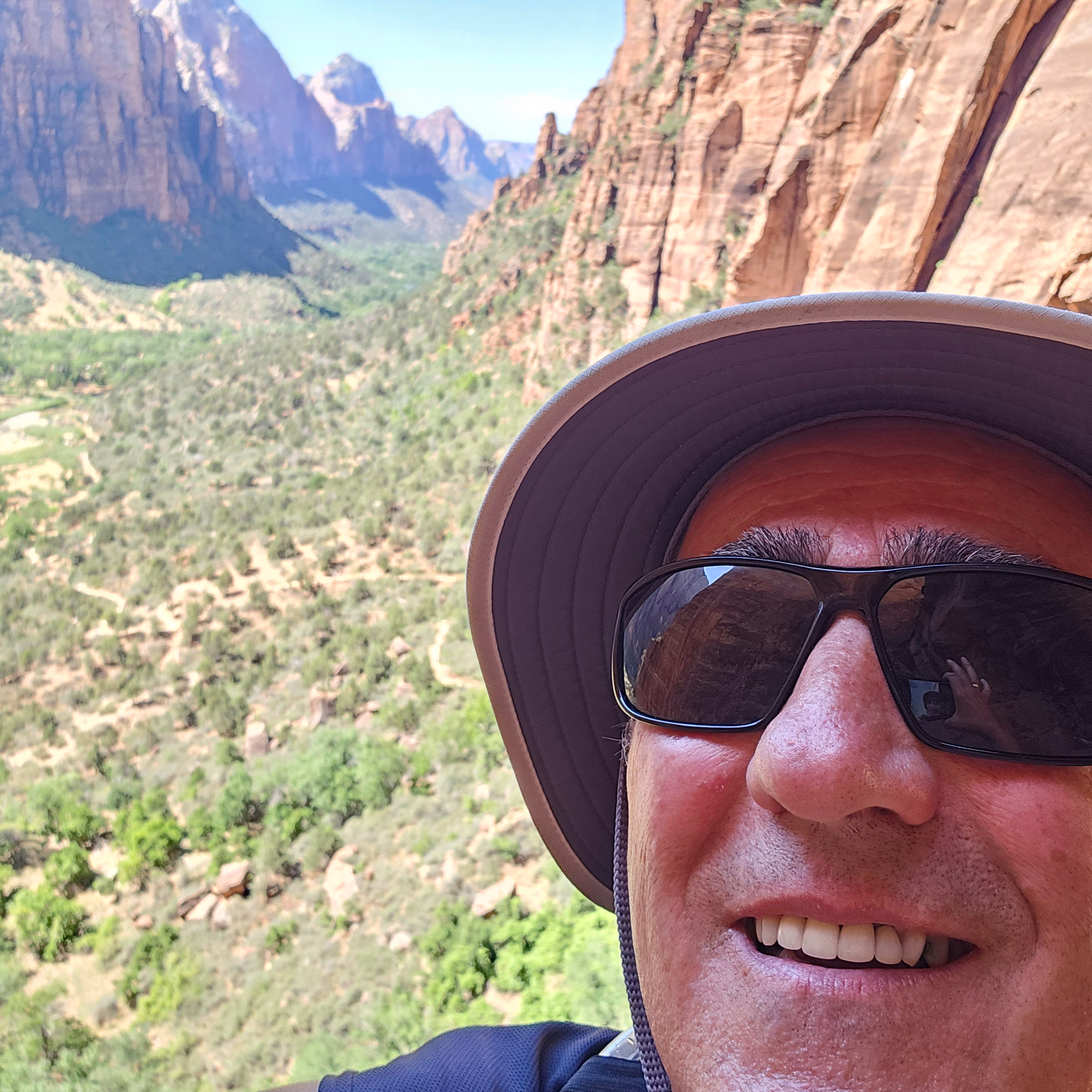
Al got to his Trail Head and got off. Then road it back to the visitor center where I looked through the gift shop, found a cool place to sit and I waited and I people watched. Some VERY interesting People--sights!
Here are a few of his gorgeous photos and his smiling face!
You can just see it a little but the Colorado River flows through this valley.
I started questioning my sanity when I saw the wall ahead of me with people zig zagging back and forth looking like ants on the switchbacks!
Starting my ascent.
The trail was paved up to this walk bridge which made the climb much easier that climbing up steps.
This sections was interesting with a bunch of retaining walls built to form the switchbacks going up.
I made it to Scout Lookout!
I looked down this crevice between the rocks and was shocked that the cliff was straight down for at least 1000 feet!
This was from on top looking up the canyon.
There wasn't much vegetation up here but I did find a nice shade tree to sit under while eating some lunch.
This is a photo of Angel's Landing. This hike requires a permit and gets way overcrowded.
I zoomed in to get this shot. As you can see it's way too crowded, not fun in my opinion.
This is looking down the valley.
This is what the trail looks like from up above. Even though the trail is paved it still tests your leg strength!
Thursday June 27, 2024
Cedar Breaks National Monument
Marley came along. We drove to Cedar Breaks National
Monument. It was gorgeous! The monument includes 6,155 acres and is included in
the Colorado Plateau. The highest peaks and overlooks in the park are over
10,000 feet in elevation. HUGE Lava
fields going up the mountain! 20 degree difference in temperature from
Panguitch to Cedar Breaks.
Panguitch Lake was originally a large natural lake that has
now been expanded by the creation of a 24-foot dam to create a reservoir with a surface area of 1,248 acres. The lake, which drains into the Sevier
River is located on the Markagunt Plateau, between Panguitch, Utah and Cedar
Breaks National Monument. It was beautiful!
90 million years ago present day Utah and northern Arizona were covered with an ancient sea. Mountains further west shed sediments like sandstone, limestone and shale. These sediments were carried toward the ancient sea. As the ancient sea drained, it exposed rock formations created by compressed layers of sediments. You can see these layers of different compressed sediment throughout Utah and Northern Arizona today.
Marley likes to explore too!
There were many dinosaur bones found at Cedar Breaks.


Scenic ByWay 12
The Scenic Byway 12 is very long and the other end goes to Torrey where our next campground is so we decided to do the drive in two sections. We drove this section as far as Escalante.
Smokey used to say "Only you can prevent forest fires"!
Bristlecone Pine Tree
We had a guy at the Visitors Center in Kanab tell us that we could tow our 5th wheel to Torrey on this road. I don't think so, it's a good thing we have RV Trip Wizard to keep us away from these roads!
We went through several small towns including Henrieville, Tropic, and Cannonville.
Escalante is about the halfway point on the Scenic Byway.
This is at the Visitors Center in Escalante for the Escalante National Monument.
Looks like the bank in Escalante UT is flourishing!
Marley came along. We went trough Red Canyon again and on up to Bryce Canyon National Park. This park is MUCH less busy and the parking lot at the visitor center was almost empty at 8:00 am. We drove on to Sunset Point and Al went on his hike though the HooDoos. We continued on and finished visiting the last couple of scenic vistas that we missed. We went on to do half of the Scenic Byway 12 Tour. Good thing I packed sandwiches and snacks! We found a little park in the small town of Escalante and had a picnic.


We drove through the Grand Staircase-Escalante National
Monument. This monument is rock and mountain formations that show the different
layers deposited and worn away over millions of years. It extends from northern
Arizona to the middle of Utah. The monument is also named for the series of benches and cliffs that step progressively up
in elevation from south to north.
A carved relief maps shows this best but...
The rock layers have been uplifted,
tilted, and eroded, forming a feature called the Grand Staircase, a series of
colorful cliffs stretching between Bryce Canyon and the Grand Canyon. The
bottom layer of rock at Bryce Canyon is the top layer at Zion, and the bottom
layer at Zion is the top layer at the Grand Canyon. Made up of five defining
“layers,” the oldest layers of the Grand Staircase are found at the North Rim
of the Grand Canyon, while the newest layer makes up Bryce Canyon. Starting
with the oldest layer first, the stair steps are named for their general color:
chocolate, vermillion, white, gray, and pink.
Clarence Dutton and John Wesley Powell named the Grand
Staircase. In 1875 Dutton went to work for John Wesley Powell, the one-armed
explorer who had just been the first one to navigate the Colorado River through
the Grand Canyon. When Powell became the director of the new US Geological
Survey, Dutton continued as his assistant, his responsibility being to map the
Grand Canyon.
You've already seen several examples of this in past posts, and will see more as we finish up Utah. You will notice layers of different colors in the cliffs as we go along.


Marley went walking with us once and had to be carried back...too much for him! He likes riding in his hot rod four wheeler!


We discovered there is no food in this park except a pricey
lodge. We ended up grabbing a burger in Bryce Canyon City outside the park. $30
for two burgers and 2 fries. Fast food like Culvers, order yourself and wait on
yourself. But they had a tip jar ready!


1 comment:
Awesome photos!!!
Post a Comment