This blog is about the next chapter.... about love, about life and about adventure! It is for our family and friends to follow along... so they know where we are! Catch us if you can!
We stayed at Thousand Lakes RV Park in Torrey, Utah. Torrey was settled in the 1880s and is named after Colonel Jay Torrey, one of Theodore Roosevelts Rough Riders.
The view from our campsite was gorgeous!
We enjoyed this RV park. It was clean and well kept (especially compared to the last one!). There was a restaurant onsite. The store and giftshop was actually huge for a campground! The only downside was the laundry was very small. There were two laundry rooms but each only had two washers and two dryers. We split up laundry into two days.
Stopped at
the Visitor Center to make a plan. We went into Capitol Reef to an old
homestead and bought jam. Capitol Reef was designated a National Monument in
1937 and redesignated a National Park in 1971.
The Eastern High Desert is a place where dinosaurs once roamed, a place that is similar to the planet Mars or to our own moon. It’s in the area between Canyonlands and Capitol Reef. Hollywood used the region for the backdrop of two movies, Disney’s "John Carter of Mars" and "127 Hours."
Robber’s
Roost—When Butch
Cassidy and his Wild Bunch needed a place to hide, Robbers Roost was their
go-to spot. This remote area was the perfect spot. Sisters Ann and Josie Basset
visited and provided food and horses. The hide-out was never discovered by
lawmen and the corral still stands today. Blue John Canyon was named after
Butch Cassidy’s cook.
The Robber’s
Roost (specifically the Blue John Canyon) area is also the backdrop for the
movie 127 Hours. In 2003, hiker Aaron Ralston rescued himself by cutting
off his arm after being trapped for 5 days beneath an 800-pound boulder while
exploring the canyons alone.
So super windy, I had to hang on to my hat!!
19th century settlers colonized a village they called Fruita named for the many fruit orchards in the area. Visitors can stop and harvest whatever fruit is in season including apricots (which we tried), plums, pears, peaches and apples.
The Gifford Homestead is full of gifty items but they seem to be famous for their pies. We bought jam. The pies were the small "pot pie" size for $8.
The only grocery store we found in Torrey. Interesting. Part grocery store, part gift shop.
There are Petroglyphs on both of these photos. Can you find them?
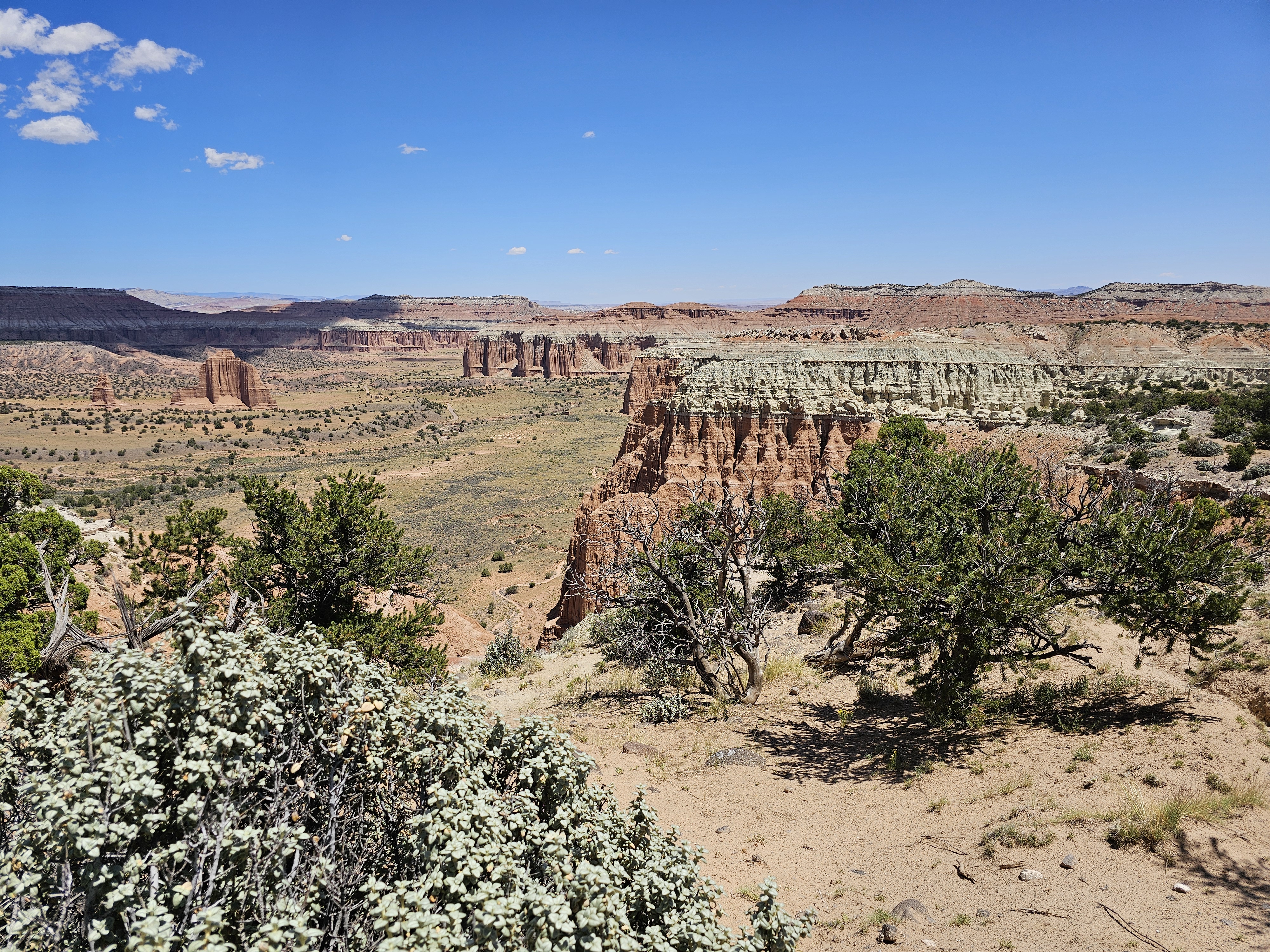
Waterpocket
Fold—This geologic
feature of Capitol Reef is nearly 100-mile-long fold in the Earth’s surface.
This warp in the earth’s crust contains numerous eroded pockets that hold
rainwater and snowmelt, giving the area it’s name.
There are many, many different beautiful scenes and formations along the Waterpocket Fold. Here are only a couple. These are along the road to our RV Park.
FISH LAKE
Fish Lake is at an elevation of 8843 feet and is one of the largest Mountain Lakes in Utah. It is 5.5 miles long, 1.5 miles wide, has a depth of 170 feet and covers 2500 acres.
INTERESTING TIDBIT----As we drove down this road, we saw signs for the Pando Tree. We never heard of this before and didn't think much about it. All we saw was a forest of "aspen trees" that was beautiful! Well, we should have stopped. Turns out, that was The Pando Tree! Of course I had to research. Here's the story...
High in the mountains of the Fish Lake National Forest stands the Pando, the world's largest tree, an aspen clone made up of over 40,000 branches (aka "stems"). Although each branch appears to us as an individual tree trunk, they are genetically identical parts of a single tree operating over 106 acres. To imagine how a Pando works, face your palm up, make a fist, then raise your fingers upward. The root bed is your palm and the branches are your fingers. Just as a tree in your yard works, Pando acts as one tree. It's a process called "suckering" where the roots send up new shoots that become branches (what we see as individual tree trunks). Weighing 13.2 million pounds, Pando is 3 times larger than the largest single tree and, twice as large as the next largest aspen clone (106 acres versus 47 acres). Pando is so big in fact, it was not "discovered" until 1976, when Burton Barnes flew over the tree in a plane and noticed the outline standing out from surrounding trees. In 1993the tree was named "Pando", Latin for "I spread". In 2008 researchers confirmed Pando's size using genetic tests. Scientists believe that the individual Pando seed took root between 8000 to 13,000 years ago. The Pando can grow 3 feet per year. Each Branch (trunk) can grow to 80 feet tall, 3 feet around. Interesting, right?
This tiny little building was the Visitor Information. We always stop at these and most times the rangers or other attendants are full of information and willing to give advice and maps. The woman in this Visitor Center told us her husband is from the Midwest and loves the trout fishing here.
Fish Lake Area
We had lunch at a nice little shelter.
Fish Lake
We continued wandering down the road...
Dutch Belted Cows...came from the Netherlands. This was just outside of Loa.
Marley kept a close eye on those Bison!
Cathedral Valley
The Fruita Schoolhouse
Found this little old schoolhouse and peeked in the window...
Rented Jeep
from RV Park. Drove across a river and followed a dirt and rocky road for 70
miles. No bathrooms! Finally found a pit potty and picnic table before I burst!
Had lunch then more bumpy roads, pull offs and vistas.
This little campground for tent campers was literally in the middle of nowhere. It was a nice lunch spot too!
Fins--Rock formations that look like shark fins.
The thin dark formations are called "fins."
The
Gypsum Sinkhole was
formed when groundwater dissolved a buried gypsum plug. The cavity left behind
has collapsed under the weight of overlying rock layers. This collapse has
created a large sinkhole nearly 50 feet in diameter and 200 feet deep.
Temple of
the Moon is a 5,665-foot elevation summit located in Capitol Reef National Park
I felt like we were driving on the moon....and then I saw this "moon man rock." Do you see it???
Tidbit---The Mars
Desert Research Station near Hanksville is the second of four simulated Mars habitats in the
world. The area was chosen for field study research because of the terrains
similarities to Mars. Astronauts and research crews spend two weeks at a time
living in the two story, eight meter cylindrical ‘habitat.’ They are required
to wear space suits and carry walkie talkies whenever they step outside the Hab
into the simulated Martian environment.
Here is the video of our 70 mile Jeep tour...
We ate at this Mexican Restaurant in Torrey. The name means "Red Jaguar."
SCENIC BY-WAY 12--Over Boulder Mountain
Boulder
Mountain, part of the Dixie National Forest, is 11,322 feet high with about 50,000
timbered acres and 2 million acres total, that cover half the Aquarius Plateau
(an uplift along the Colorado Plateau) making it the highest forested plateau
in North America. There are over 100 Lakes, ponds, and streams.
We wandered
the Scenic By-Way 12. Another long day! A famous stretch of the two-lane
by-way known as “The Hogback” runs along a thin razorback ridge of slickrock,
with sheer drop-offs on each side. Driving was slow and cautious! Al was
hanging on tight!!
We stopped at the Wildcat Guard Station on the mountain. It's a cute log cabin build by the Civilian Conservation Corps in 1935. Years ago it housed seasonal US Forest Service employees. Today it is a seasonal visitor center. It was super cute inside! Wood floors and wood stove and the kitchen still had the old wood stove to cook on. There was a porch on the front and the back.
Boulder Town was long known as the "last frontier in Utah," The high elevation was so isolated that, until 1935 mail was delivered by horseback and fresh milk was delivered by mules to the nearby town of Escalante. That milk often turned to butter on the rough routes over slickrock. First settled in 1894, the town was named for the volcanic boulders scattered across the slopes of nearby Boulder Mountain.
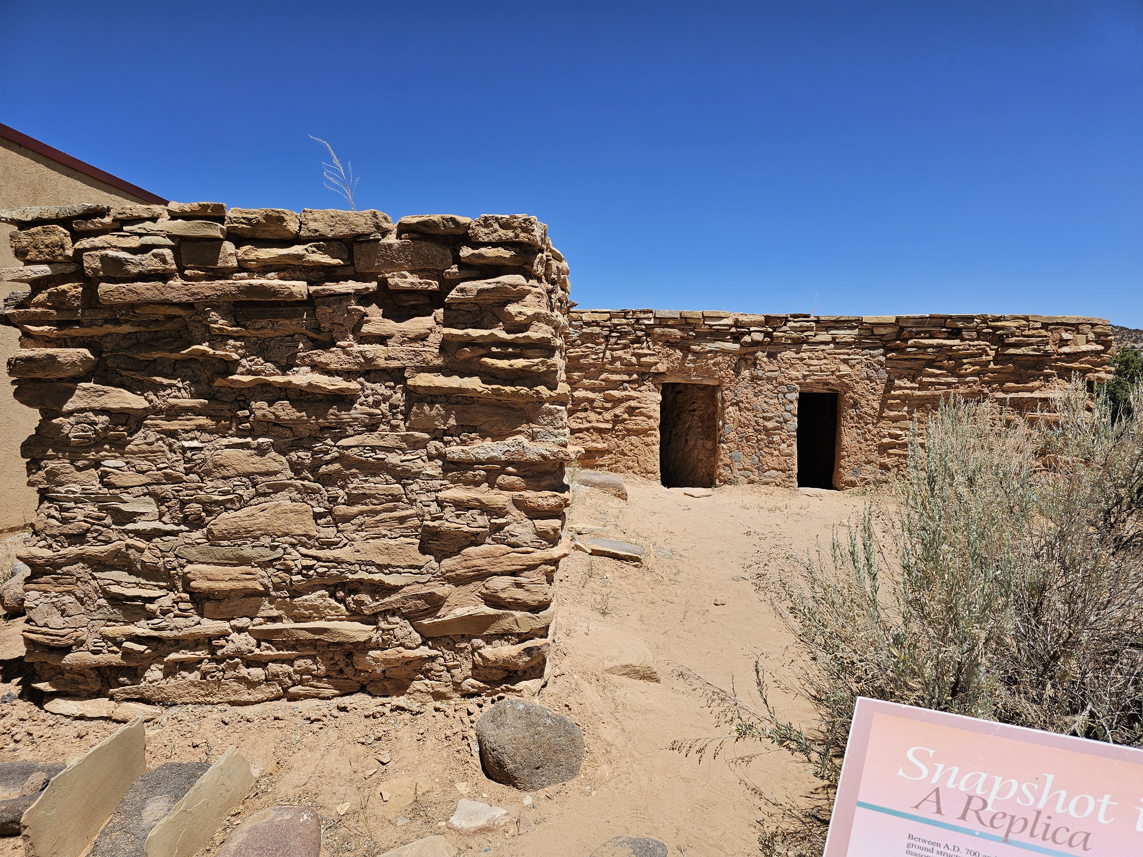
Anasazi State park Museum in Boulder
The museum is located on the site of an Ancestral Puebloan site that archeologists believe was occupied between A.D. 1050 and 1175. There are almost 100 rooms excavated and reconstructed as well as many artifacts.
The Anasazi State Park had a picnic area so we chose to have our lunch here.
We stopped at many overlooks! Al went wandering...
Amazingly, there was a coffee and sandwich shop perched on the side of a mountain, in the middle of nowhere! Seriously, nothing else around for miles. We had iced coffee.
HICKMAN BRIDGE & OVERLOOK
Al went
hiking early to beat the heat. Hickman Bridge and Rim Overlook in Capitol
Reef-Fruita Area. Hickman Bridge is a huge natural arch spanning 133 feet wide
and 125 feet tall.
I met a young man name Ryan from Las Vegas, Nevada and we traded phones to take photos.
I'm always fascinated by these survey markers way out in the sticks. I know from my work as a surveyor how difficult it is to get the level of precision required for these monuments and placing them in solid rock would be quite a challenge!
It was difficult to follow the Rim Trail over the slickrock, luckily there were enough Cairns (trail marker) to follow!
Rim trail is about half mile above the trailhead off the highway. I sent Cashton a photo from up here and when I told him how high up I was he said "that's half way down the Grand Canyon! LOL The road in the background is the Capitol Reef scenic drive. Unfortunately for us it was closed and under construction through 2025.
Originally I was going to hike to Navajo Knobs in the background but it was already getting too hot so I headed back to the trailhead.
I found this unique boulder where the water created a "handle" in the rock.
This formation is the Pectols Pyramid. If you look closely on the face of the cliff there is another shape that also looks like a pyramid.
Black
Round Boulders
everywhere! The black Boulders were transported from Boulder and Thousand Lakes
mountains over 20 million years ago when lava flows covered the mountains here
with andesite, a volcanic rock. Over the last 150,000 years, small glaciers
broke the rock into pieces that tumbled here in landslides and floods, rounding
on their journey.
I took this photo of the rim I hiked up to from the roadway by the visitors center.


No comments:
Post a Comment