
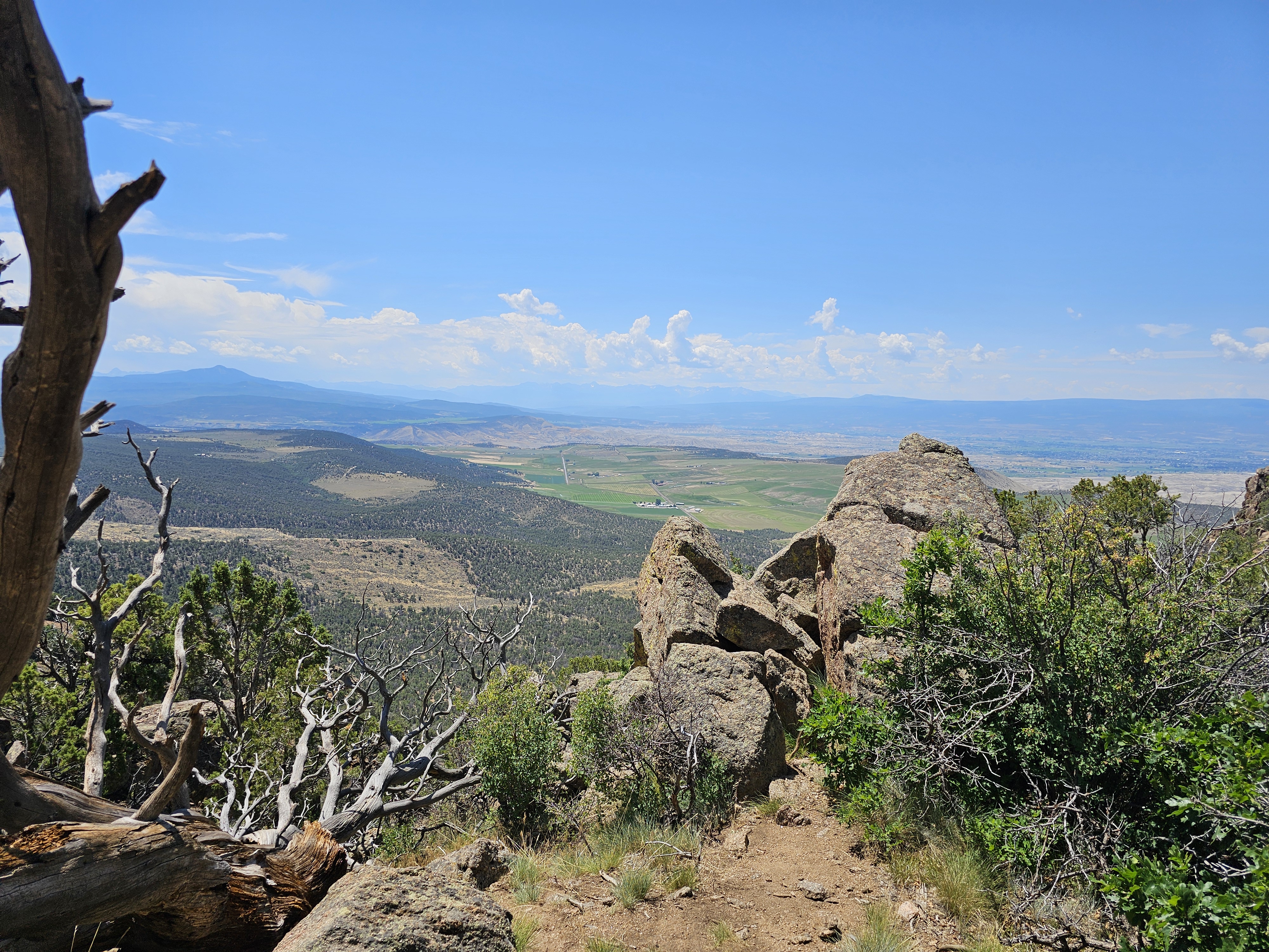
Black Canyon of the Gunnison was first named a National
Monument in 1933 but didn’t achieve National Park status until 1999 (the 55th
of America’s National Parks). The sheer granite cliffs were carved by the Gunnison
River millions of years ago. The Black Canyon, so named because the walls are
often shrouded in shadows making them appear black, has some of the world’s
oldest exposed rock — Precambrian or “basement” rock that is nearly 2 billion
years old.

The rocks that make up the Black Canyon are some of the
oldest in North America, dating back to 1.7 billion years old.


The cliff walls are 40 feet apart at the river and rise 1750
feet to the rim.


The rim of Black Canyon sits at 8,000 feet above sea level
and some of the walls reach 2700 feet above the river.

Al did all the walks and hikes… Happy Birthday to you, Al!
Tomichi Point
Gunnison Point
Pulpit Rock Overlook
Cross Fissures View
Rock Point
Painted Wall View
Dragon Point
Sunset View
Warner Point


John Williams Gunnison led an expedition to explore the
canyon. On September 7th, 1853, the expedition first glimpsed the relatively
tame section of the Black Canyon at Lake Fork. The report of the expedition
described the area as "a stream imbedded in a narrow and sinuous canyon,
resembling a huge snake in motion." The report continues, "To look
down over...the canyon below, it seems easy to construct a railroad; but
immense amounts of cutting, filling and masonry would be required." Even
then, these experienced explorers understood the geologic processes that
created such an obstacle – an uplift of the earth, volcanic activity, and the
power of water.
The captain rode into the canyon several times during that
first day. He esteemed the country, "the roughest, most hilly and most cut
up," he had ever seen. Though the party never ventured further downstream,
their report contains the first official description of the formidable Black
Canyon. Future explorers were also impeded by the canyon.


The Painted Wall is the highest cliff in Colorado at 2,250
feet above the Gunnison River.


We left early and set out to explore the Million Dollar
Highway to Silverton. A beautiful but SCARY drive!


The Million Dollar Highway, nestled high in Colorado's San
Juan Mountains, is considered one of the most dangerous roads in America — and
one of the most scenic. There are no guardrails due to the high amount of snow
in this area and because the roads are so narrow if there were guardrails the
snowplows would have no where to put the snow.
At Red Mountain Pass, the Million Dollar Highway reaches its
highest point — 11,018 feet — and ruins of abandoned mining camps are visible.


Along the way, we pulled over to take a photo of a cool bridge and looked the other way and found this! The Idarado Houses Project. The project includes several Miner Homes and initially the mining company owned the property with investors. British investors backed out because of a European War going on at the time. They stayed empty and then in 2016 the county started planning how to get the mining company to donate the land. The white colored houses on the tight-S curve at milepost 82 on U.S. 550/Red Mountain Pass are known as the Idarado Houses, and they were originally built before 1920 for miners and their families in the now-abandoned ghost town of Eureka, Colorado, northeast of present day Silverton.


In 1860,
Charles Baker and several prospectors entered the San Juan Mountains in search
of wealth. They soon found deposits of gold and silver along the Animas River,
in an area that was later called "Baker's Park". The prospectors
stayed through the summer but returned to what is now northern New Mexico for
the winter. News spread of the discovery; however, with the Civil War looming
and the discovery being located on Ute Indian land, the miners did not return
to the San Juan Mountains until early 1870s.
At that time
nearly 1,000 prospectors once again ventured into the high country. The Utes
protested, yet they could not stop the inexorable wave of miners and settlers
that arrived over Stony Pass.
The Brunot
Treaty was negotiated with Chief Ouray and the mountains were opened to the
settlement.
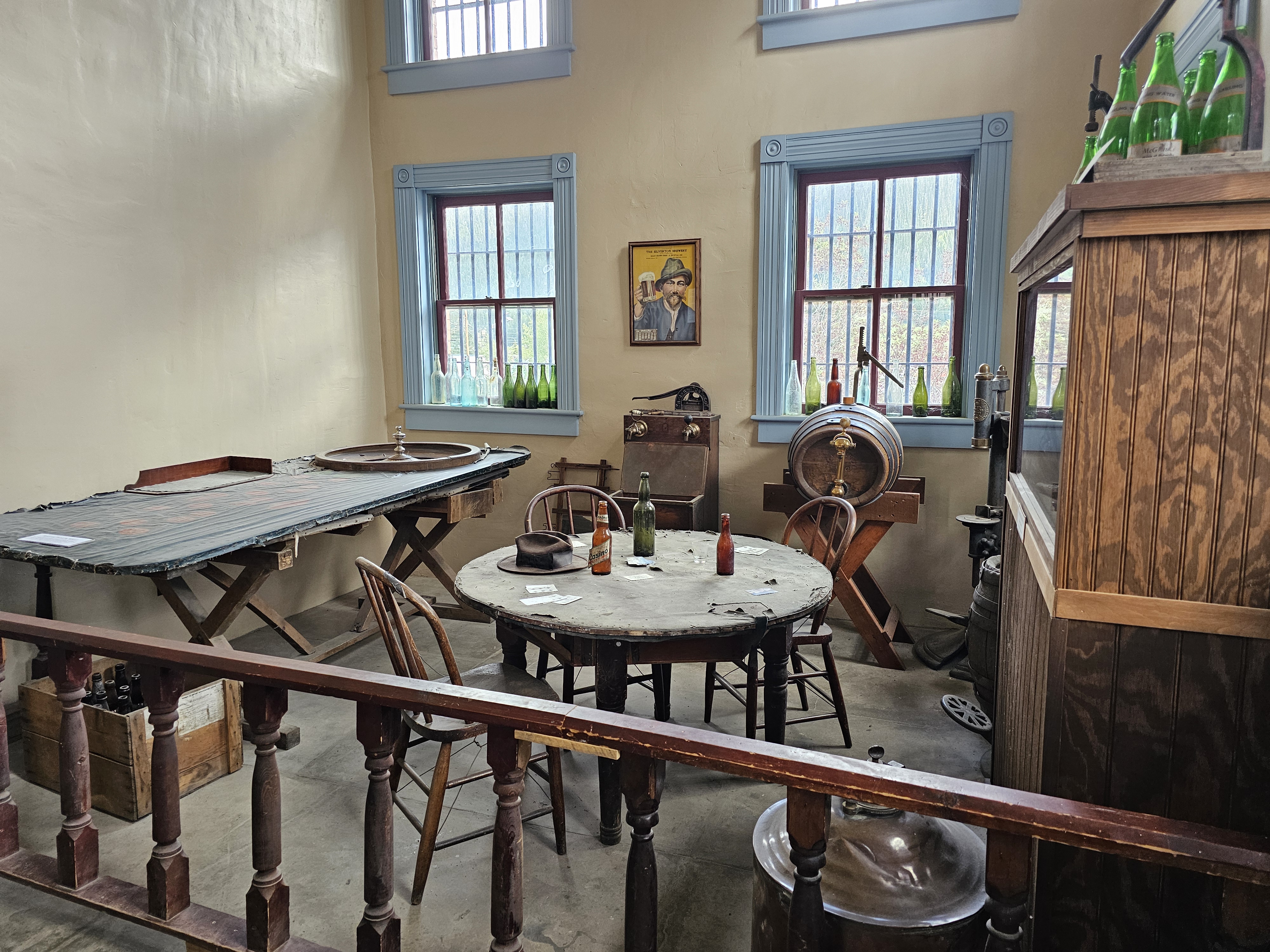
Silverton which is the last mining camp standing in the county, is in the heart of the San Juan Mountain’s ancient Caldera bowl.
The 1900 census reported over 2300 people (today only 600 permanent residents live there) in the county and in 1901 there were 137 telephones in Silverton. Silverton was booming! They built a courthouse and jail, a hospital and a library. They also had water and sewer put in and a municipality run electric company.

In 1874
Silverton's town site was laid out and it soon became the center of numerous
mining camps. In addition to the miners, Silverton caught the eye of a railroad
company in Denver. In July 1882 the first train operated by the Denver &
Rio Grande Railroad rolled in to Silverton from Durango. By 1883, Silverton
boasted of having a population of 2,000 people with 400 buildings - 2 banks, 5
laundries, 29 saloons, several hotels and a bawdy red-light district -
Notorious Blair Street.


As early as
1874, men were bringing their wives and families to live in Silverton. This
influx of families provided an incentive for citizens to keep at least part of
Silverton respectable. From the very beginning an imaginary line ran down
Greene Street dividing the town between the law-abiding, church-going residents
and the gamblers, prostitutes, variety theatres, dance halls and saloons.


In May 1883
a grand jury brought 117 indictments against "lewd women" on
Notorious Blair Street. Although fines were levied, gambling and prostitution
were generally accepted as long as the practice did not migrate into the more
respectable sections of town. Lascivious behavior was not necessarily
condemned, as fines were readily used for the growing community.
When miners took a break from their work, often after weeks or months of working and living at the mines, many headed for Blair Street in Silverton. In a three-block area, there were 29 saloons, dance halls, and houses of ill-repute, designed to inspire men to blow their entire paycheck in one spree. There was a tunnel under the hotel to Blair Street so men go in the front door of a respectable business and go down through the tunnel to the Madam’s businesses.
Although
illegal, gambling and prostitution were tolerated in early Silverton as long as
the Ladies stayed behind the “invisible line” separating them from the more
“respectable” part of town.
The old
saloons on Blair Street were reborn in the 1950s as movie sets where Westerns
such as Run for Cover and Across the Wise Missouri, and True Grit were shot with
the train as it’s “star”.


2 comments:
I could feel the steep decline in the video of the Million Dollar Highway. I also watched Jesse's Drone Adventure video and seeing the drone footage was downright scary!
Loved the way Marley had a cheesy smile in that one picture! 😍😁
Love the historic buildings, but not the chicken paws. 😉
Post a Comment